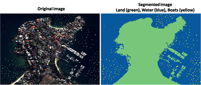
LiDAR (light detection and ranging) is a popular remote sensing method used for measuring the exact distance of an object on the earth’s surface. From vegetation index identification to self-driving car, in each field LiDAR data is used to solve problems. Let me show you some ideas, what can be done by LiDAR data.
Another advantage is, you can analyse large area of earth at once by doing LiDAR data analysis.
Related Articles:
- How to Download LiDAR Data free
- 3D Digital Surface Model with Python and Pylidar
- Clip Raster with a Shape file in Python
- Download High Resolution Satellite Imagery free online
- How to Create Boundary shape file from LiDAR data
Types of LiDAR data analysis
· Detect any object from LiDAR data
· Extract vegetation index using LiDAR data: This type of analysis is called NDVI (Normalized Difference Vegetation Index) analysis. By this analysis you can find greenness (ranging from 0 to 1) of a large area. This type of analysis is very helpful in agriculture.
· Object Segmentation
· Population Growth analysis
· Damage analysis after storm or flood
· Canopy Height Model (CHM)
· Etc.
Now we know what can be done using LiDAR data. Looks interesting right? At this point you some questions in your mind like:
· What is LiDAR data?
· How is LiDAR data collected?
· Tools to analyse LiDAR data
· Where to download free LiDAR data?
In this post I will try to answer those questions.
What is LiDAR?
LiDAR (Light detection and Ranging) is a distance technology that uses light in the form of a laser pulse to measure height of any object (like tree, building etc.) from the earth.
There are various technologies to map anything on earth like:
Sonar: Uses sound wave to map any object. Primarily used in submarines to navigate, communicate with or detect other objects on or under the surface of the water.
Radar: Uses radio wave to map any object. It is used to determine the angle, range, or velocity of any object. It can be used to detect ships, aircraft, spacecraft, motor vehicles, guided missiles, weather formations, and terrain etc.
Similarly LiDAR uses light to map any object on the earth.
How is LiDAR data collected?
LiDAR data can be collected from Aeroplane, Drone, Helicopter or Ground or Satellite. Let’s see how LiDAR data is collected from Aeroplane.
From Aeroplane LiDAR systems send light in the form of laser pulse to the ground.
This pulse hits the ground and return back to the sensor. Then calculate how long it takes for the light/ pulse to return back to the sensor.
By calculating the return time, LiDAR measures distance of each point of each object on the earth.
Tools to analyse LiDAR data
Here are top tools for doing LiDAR data analysis
· ArcGIS: Most common and popular software for doing LiDAR data analysis. You can use ArcGIS software (ArcMAP, ArcScence) or you can use ArcGIS python API/ library to do LiDAR data analysis. Note: ArcGIS is not open source software or library. You need to purchase it.
· QGIS: You can also use QGIS software to doing Light Detection and Ranging data analysis. QGIS is similar to ArcGIS.
· LAStools: LAStools by rapidlasso. You can use this software for doing 3D point cloud data (LiDAR data) analysis. This software is available as open source (some limitations are there) and on purchase version.
· Python: Yes you can use python for doing LiDAR data analysis without purchasing anything. There are some open source libraries like: GDAL, PDAL, Rasterio, Pylidar which you can use.
Where to download free LiDAR data?
There are lot of sites you can download LiDAR data free. Sharing some of them which I found easy to access and download.
· USGS (United State Geological Survey): You can download LiDAR data, high resolution and multiband satellite imagery from this site. You just need to do free registration and after that you access download data from various satellites.
· USGS National Map Viewer: You can download LiDAR point cloud data and 3 band (RGB) satellite imagery from this site. No need to register. Just visit select and download.
Common format of LiDAR data
Most common format of LiDAR (point cloud) data:
· LAS
· LAZ
Most common format of satellite imagery
· TIF
· TIFF
· JP2
Conclusion
LiDAR data analysis is most effective if want to analyse large area of earth. For example if you want to analyse or track any changes in earth for a certain boundary LiDAR data analysis can help you to do that.
If you have any question or suggestion regarding this topic see you in comment section. I will try my best to answer.


Good read. Thanks for sharing this article.
Mate, I like your summaries on this page. It gives the skeleton of what I was looking for to start my research project. With this, I can go on and research details of what I am looking for. I am doing a PHD in remote sensing using InSAR and LiDAR to monitor CSG impacts, mainly subsidence.
Thanks. Best of luck for your research.